3 questions to address AGV and AMR navigation
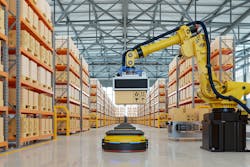

Automated guided vehicles have been around since the 1950s. However, not surprisingly, the technology has advanced significantly. Traditionally, AGVs used downward-facing sensors to follow physical markings on the floor, such as lines or magnetic tape. Modern versions are easier to install and offer more route flexibility. They follow a line, too, not a physical line, but more of a digital line.
It entails programming the AGV to answer three questions for itself:
• Where am I?
• Where am I going, and what is my mission?
• How do I move there?
Where am I?
Automated guided vehicles store locational data as x and y coordinates on a site map that sits electronically on the vehicle or, with a wireless connection, remotely on a server. Vehicles typically use one of the following techniques to maintain localization as the vehicle moves about the site:
• laser triangulation, also called laser-guided navigation (LGN)
• vision guidance, also called optical navigation
• natural navigation, also called simultaneous localization and mapping (SLAM), free, contour or mapping navigation.
Laser triangulation uses three references to triangulate the position of the AGV. Lasers on top of the vehicle bounce off reflectors installed around the environment. Lasers need to be high on the AGV to avoid obstacles, and the initial installation of the reflectors and survey to create the virtual map can be expensive and take several days. The cost of maintenance and project modification, however, is relatively low, and this software-based technology is a good choice if fleet management is required.
With vision guidance, a camera is installed on the vehicle, which recognizes features in the site and compares them to a 3D map of its environment and can calculate its position from there. Or the user may have configured the site by driving the AGV along the desired route to teach it its path, constructing the 3D map from continuously collected images. Although such vehicles are quick to install, the system can be sensitive to changes in environmental light, which may limit its accuracy and reliability.
Natural navigation uses 2D scanners, usually the vehicle's safety scanners, to either compare the AGV's surroundings with a previously created grid map of the site or to natural features saved in its site maps, such as walls and permanent machinery. Like laser guidance, both approaches use virtual paths, meaning projects are easy to modify and advanced fleet management is also possible. The grid-based approach does, however, require the system to recognize approximately 60% of its environment to calculate the vehicle's position accurately. This makes it sensitive to modifications in the environment.
Where am I going, and what is my mission?
Once a navigation system knows where the vehicle is, it can move or virtually guide the AGV or AMR along pre-defined routes, performing actions, such as slowing down or raising forks, at set points.
Routes and actions are usually programmed using the navigation system’s software. One approach, for example, places virtual nodes throughout the site map, which are then connected with links that can be programmed to be single or bi-directional, depending on a project's requirements, while actions are programmed into the nodes.
How do I move there?
Once the AGV knows where it is, where it needs to go and what to do—en route and on arrival—the vehicle’s control system drives it, carefully controlling the vehicle's movement, including its speed and trajectory.
Some autonomous navigation solutions provide this control alongside the localization capabilities, meaning that only the vehicle’s maximum speed must be defined, which can simplify a vehicle's installation and operation. Whatever solution is selected, the control system should be designed to optimize the vehicle’s schedule, while ensuring safe operation and payload stability. The control system also manages encounters with obstacles such as other vehicles, people and pallets that have been dropped on the floor and would be able to stop and let them pass or avoid them.
Nicola Tomatis is CEO at BlueBotics SA.